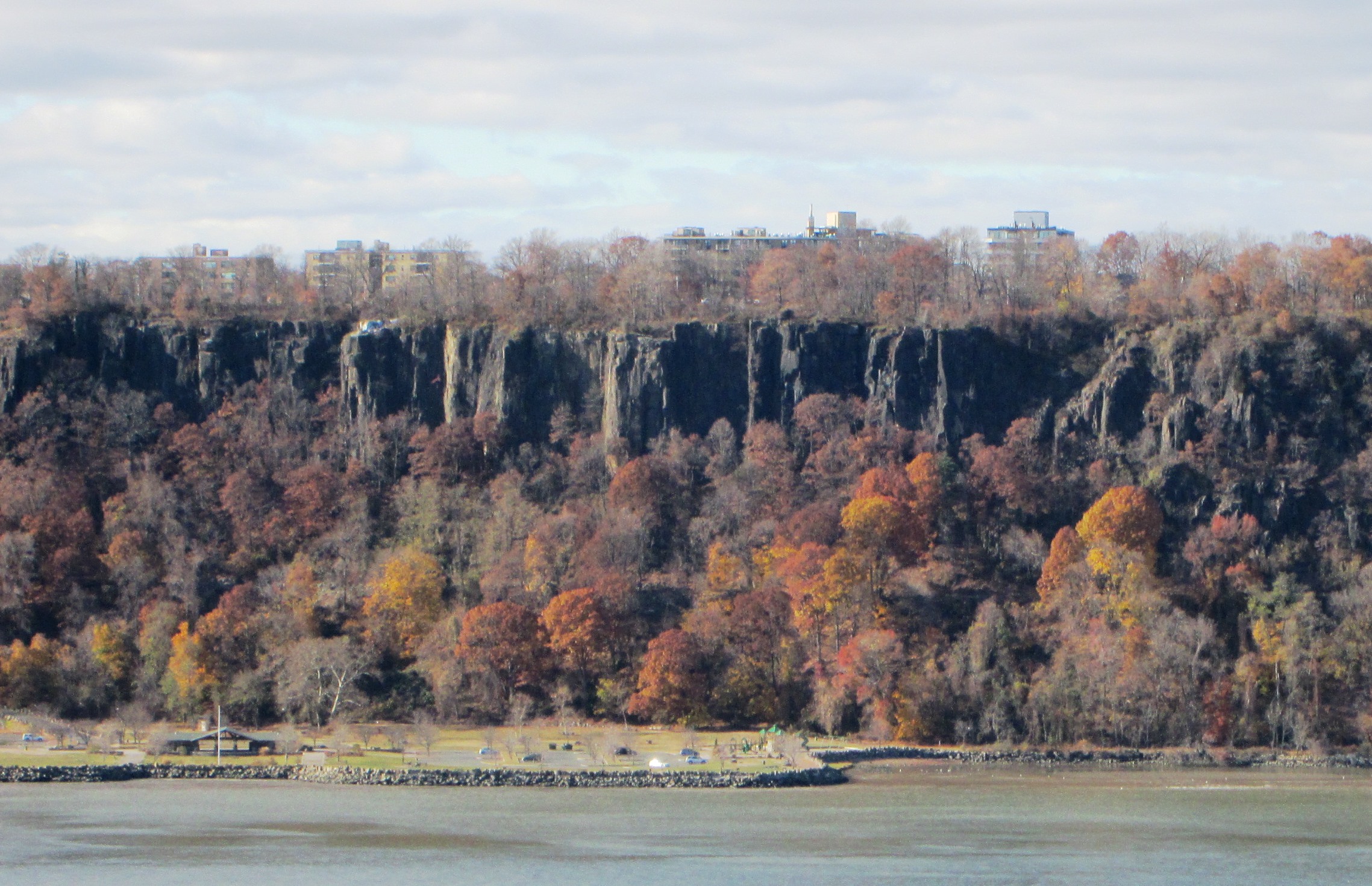
Just across the Hudson from New York City,
cliffs of dark gray rock rise almost vertically some 500 feet above the river,
sometimes clothed with vegetation and sometimes just bare rock. This is the New Jersey Palisades, a solid
wall of rock stretching from Fort Lee northward as far as the eye can see, all
the way to the New York State boundary some twelve miles to the north. Huge signs advertising patent medicines and
other worthy products once blazoned forth their message from the cliffs for the
benefit of steamboat passengers in the years following the Civil War
(“Obscenery!” proclaimed Horace Greeley of the New York Tribune), and
the rock itself was once quarried for railroad ballast. And when, in the late 1890s, a movement
developed to preserve the Palisades, the quarry operators used dynamite to
speed up their work before conservation efforts put an end to it. Fortunately, those efforts soon paid off;
quarrying ended in 1900 with the creation of the Palisades Interstate Park
Commission by the governors of New York and New Jersey. In time, the Park Commission would undertake
to acquire for the park all the private property both below the cliffs and on
top of them. In 1933 John D.
Rockefeller, the robber baron turned philanthropist, donated to the Park
Commission all the land he had acquired along the cliffs, on condition that the
Commission acquire all the estates not owned by him and demolish their
mansions, so as to restore unobstructed views of the river.
 |
| Beyond My Ken |
This park is a long, skinny stretch of
green squeezed in between the Palisades Parkway and the cliff edge, often only
an eighth of a mile wide, so that you can’t possibly get lost in it, but you
are constantly serenaded by the sound of zooming traffic. I have often hiked the length of it, though
not all at once but in segments. Two
paths traverse it: the Long Path along the top of the cliffs and, far below,
the Shore Path along the edge of the river; each has offered me a climactic
experience, unique, at the end of my hike.
There are three real dangers in the park, two of which I have
encountered; I shall deal with them all in time. Let me now relate a hike on the Long Path,
which is easily accessed just over the George Washington Bridge (which I have usually
walked) in Fort Lee, New Jersey.
The Long Path
 |
| Famartin |
Pressing on along the trail, which is
marked with turquoise blazes, I passed the remnants of foundations of former
mansions that always puzzled me, until, researching this post, I learned how,
at Rockefeller’s insistence, the Park Commission acquired and demolished them. At times I would go to the cliff edge and
look back at the bridge, measuring my progress by how much it had retreated
into the distance. Its sounds faded, but
those of the nearby parkway persisted, and my quest of solitude in nature was
further frustrated by the presence of a roadside gas station. Just beyond it, however, I would come to
Allison Park, a small, well maintained bit of greenery offering a nice view out
over the Hudson, benches for picnic lunches, and water fountains and rest
rooms. It is named for the first mayor
of Englewood Cliffs who once had an estate here and was a leader in the
movement to preserve the Palisades.
Continuing north through the oak forest
that prevails here, I would come to High Tom, a rock promontory offering fine
views north and south, and then to Rockefeller Lookout, another spot for good
views, a mile north of the bridge and just across from the northern tip of
Manhattan, where the Harlem River flows into the Hudson. Here once, finding a bit of cliff just beyond
the fence that offered an unusually fine view, I stepped out onto it, settled
down, and enjoyed the vistas. At this
point another hiker happened by, saw me, and warned that in going beyond the
fence I risked arrest for reckless endangerment. He himself had been arrested on that very
spot and had been obliged to go to court and pay a hefty fine. Thus warned, I stepped back over the fence
and never transgressed again. It’s just
as well, since in the summer of 2012 alone three deaths occurred here, two
accidents and a suicide whose body was found 225 feet below the edge. Yes, the cliffs are dangerous, and if Big
Brother is out to keep you safe, however annoying he can be, his intentions are
the best. So much for the first of the
three dangers to be encountered in the park, though we’ll return to it later.
 |
| Malcolm |
 |
| The concrete bridge to Grey Crag. Famartin |
 |
| View north from Ruckman Point, north of Grey Crag. Famartin |
 |
| Famartin |
 |
| Can you make out the Indian Head? Erhudy |
Coming from the bus stop, I would pass
through a dank, shady stretch of forest, approach the cliffs, and climb up, up,
up a staircase, huffing and puffing, to reach a point almost at the top of the
cliffs, where I would emerge into morning sunlight and experience, once a year,
the climax of the trail, the goal of my annual pilgrimage. Here the path passes between the cliff edge
on one side and a sloping wall of rock on the other, and here, and here only, I
would find two spring flowers that thrive in rocky soil.
At the cliff edge, and even on ledges on
the face of the cliffs, grow clusters of wild pink, a flower with wedge-shaped
pink petals and a sticky stem: beautiful, but not to be approached too closely,
given its preference for the edge of the cliffs.
 Other rock-loving spring flowers bloom there
as well, mostly inconspicuous little mustards, but one flower growing singly
here and there on the rocky wall opposite upstages even wild pink. This is columbine, whose yellow-centered nodding
red petals with long curved spurs have always fascinated me and drawn me year
after year to this very special spot.
Other rock-loving spring flowers bloom there
as well, mostly inconspicuous little mustards, but one flower growing singly
here and there on the rocky wall opposite upstages even wild pink. This is columbine, whose yellow-centered nodding
red petals with long curved spurs have always fascinated me and drawn me year
after year to this very special spot.
I
always lingered there for at least fifteen minutes, usually having the path to
myself, bathed in the bright morning light, with the river scintillating in the
sun far below, and overhead a blue arch of sky, with one or several turkey
vultures gliding on unseen currents of air.
A magical moment, unique, not to be repeated for a year.

 |
| The flower points down, but the spurs of the red petals point up. Alan Vernon |
The Shore Path
 |
| You don't want him on you. Jerry Kirkhart |
I am informed that this area once had a
settlement called Under the Mountain, and a mix of small farms and quarries,
fishing shacks, and manure and bone factories, of which the only remnant today
is a small cemetery somewhere on an upper level that I have never seen. At intervals the remains of a dock, usually
masked by vegetation, jut out into the river; going out on them, I would get a
better view of the cliffs to the north and the south. Passing under Greenbrook Sanctuary, you come
to Greenbrook Falls, a trickle in late July and August, when I often came this
way to harvest raspberries, but an ice mass in winter and, in spring after
rain, a gushing waterfall – sights I have never seen, since I avoid the Shore
Path in winter, fearing ice on the paths leading down, and likewise avoid it in
spring, not wishing to renew my acquaintance with the ticks.
Approaching Alpine Boat Basin and its
picnic area, you come upon the Blackledge-Kearney house, dating from about 1750
and now a museum, where Cornwallis, landing his troops here in November 1776 in
pursuit of Washington across New Jersey, is said to have spent the night. His troops marched up to the top of the
cliffs by the very same switchback trail that I have often used to access the
Shore Path here. Beyond, one comes to a
place where the Indian Head already viewed from State Line Lookout is seen from
below; here, it isn’t the Indian or the patroon that is seen, but the Yankee
pioneer.
 |
| Blackledge-Kearney house. KForce |
Now, 11.5 miles north of Fort Lee, comes
the climax of the hike, the so-called Giant Stairs, a vast jumble of boulders
that over the centuries have tumbled down to the foot of the cliffs, creating a
lunar landscape such as I have never experienced elsewhere in the East. The caves and cavities under these masses of
rocks harbor raccoons, foxes, small rodents, lizards, and snakes, including the
third danger of the park, the venomous copperhead. I have never encountered any of these
creatures except a harmless little green lizard, and least of all the
copperhead, since in following the path over the boulders I make too much
noise; he doesn’t want to face me, slithers down into the dark cavities under
the rocks at the least hint of a human approaching.
I have traversed the Giant Stairs a number of
times, following the white blazes of the Shore Path as they led me up, down,
over the boulders or around them, in a zigzag path that took forty-five minutes
to cover a mere quarter of a mile. As
you scramble over or around them, the boulders have a way of wobbling, which
doesn’t make the hike any easier; in fact, you have to focus so on where you’re
stepping next, you can easily forget to survey the unique landscape all around
you, and the cliffs that tower above.
.jpg) |
| A copperhead. Look close or you won't see him. |
A sign used to warn hikers that the going
from this point on was difficult, and advised them to take a path blazed blue
and white back up to the Long Path above.
It’s not just the Giant Stairs that pose problems, since beyond it the
Shore Path is impaired by erosion; once, having survived the Stairs, I pressed
on, only to find a short section of the path completely worn away, obliging me
to drop down a few feet and continue that way, before climbing back up to the
path. So once the sign appeared warning
of the problems ahead, I would go only so far as to view the beginning of the
Stairs, then retreat to the path leading upward and return that way – an
arduous climb, even so – to the Long Path far above. Today, however, a sign simply warns hikers that the going ahead is difficult.
That’s not quite the end of the
story. On May 12, 2012, a 500-foot rock
face came crashing down from the cliffs, shaking the ground and dumping a fresh
layer of boulders onto the Giant Stairs right down to the edge of the river,
and sweeping a whole stand of trees – oak, birch, and paulownia -- into the water. Witnesses on the New York side of the river
reported hearing a sound like jet planes overhead, and seeing what looked like
a big cloud of smoke as the rocks tumbled down.
Fortunately, because the slide occurred in the evening, no one was
injured, but the path over the Stairs was closed until further notice, so heavy
machinery could be used to stabilize the boulders and make the path safe again
for hikers. So nature’s raw power can be
exerted at any moment, without warning. I
have often hiked that very stretch of the Shore Path where the rock slide
occurred, which gives food – a whole feast – for thought. Yes, the Palisades can on occasion be
dangerous, and in those cases no amount of precautions can guarantee your
safety.
Another note on WBAI: The financially beleaguered station continues to spiral downward. One fund drive succeeds another, with ever more desperate pleas for donations. I thought the award-winning evening newscast would be sacrosanct, but even that has disappeared. I now listen to Gary Null at noon, but little else. The Thom Hartmann program, replacing an informative program that I liked, doesn't hold me, when the host repeats his fund drive plea again and again in exactly the same words as before -- obviously a recording (maybe he's taking a rest break). Hartmann is knowledgeable, but his self-promotion annoys me. For the minimal donation he will give you a bumper sticker, "Graduate of the Thom Hartmann University." I usually flee to WNYC.
Coming soon: New York Mosaic: The Neighborhoods (the Diamond District, Chinatown, Soho, and much more). In the offing: items from my Inanities File of the 1960s, ranging from hilarious to sinister, but always inane.
© 2013 Clifford Browder
 |
| Taken by the photographer while kayaking on the river one week after the slide. Michael J. Passow |
Another note on WBAI: The financially beleaguered station continues to spiral downward. One fund drive succeeds another, with ever more desperate pleas for donations. I thought the award-winning evening newscast would be sacrosanct, but even that has disappeared. I now listen to Gary Null at noon, but little else. The Thom Hartmann program, replacing an informative program that I liked, doesn't hold me, when the host repeats his fund drive plea again and again in exactly the same words as before -- obviously a recording (maybe he's taking a rest break). Hartmann is knowledgeable, but his self-promotion annoys me. For the minimal donation he will give you a bumper sticker, "Graduate of the Thom Hartmann University." I usually flee to WNYC.
Coming soon: New York Mosaic: The Neighborhoods (the Diamond District, Chinatown, Soho, and much more). In the offing: items from my Inanities File of the 1960s, ranging from hilarious to sinister, but always inane.
© 2013 Clifford Browder
I was just at the Rockefeller lookout and the park just north if it on the Palisades Parkway ...what beautiful sights.
ReplyDelete